Sierra Leone has a unicameral parliament composed of directly elected MPs and indirectly elected paramount chiefs.
Sierra Leone 1 (1996)
Parliament had a total of 80 MP with 68 elected off of closed party lists according to the largest remainder system of proportional representation with a Hare quota in a single national constituency. See the page on Namibia for an example of the use of the electoral system. The legal threshold to receive a seat was effectively 4.5% (i.e. the share of the vote had to round up to 5%). Additionally, 12 seats were held by indirectly elected chiefs.
Sierra Leone 2 (2002-)
In 2002, Sierra Leone expanded parliament to 124 members, including 12 indirectly elected chiefs. At the same time, it switched to the single-member plurality electoral system for parliamentary elections. The table below shows the apportionment of seats to regions and districts since 2002.
Below are links to the 2006 report on boundary delimitation as well to map of the constituencies in place for 2007 and 2012.
2006 Report on Electoral Constituency Boundary Delimitation
Constituency Maps for 2007-12
Local Council Ward Boundary Delimitation Report, Vol. 1
Local Council Ward Boundary Delimitation Report, Vol. 2
In 2018, Sierra Leone enlarged its parliament to 146 members, including 14 indirectly elected by chiefs.
Additionally, Northern Province was split in two to create of a new North West Province. Sierra Leone also reconfigured district boundaries in this area to create two new districts, Falaba and Karene. Falaba was carved out of Koinadugu. The addition of Karene resulted in changes to the boundaries of Bombali, Port Loko and Kambia.
The 132 elected members were allocated to districts based on the 2016 Census results using the largest remainder method with a Hare quota, as shown on pp. 72-3 of the 2017 NEC Annual Report. Below are links to .pdf documents containing descriptions and maps of constituencies along with their population.
2017 NEC Annual Report
2017 Constituency Boundary Delimitation Report, Vol. 2
2017 Constituency and Ward Maps with Population Data
2017 Ward Description, Maps and Population
| APPORTIONMENT 2002-18 | ||||
| PROVINCE | DISTRICT | 2002 | 2007-12 | 2018 |
| Eastern | Kailahun | 8 | 8 | 10 |
| Kenema | 8 | 11 | 11 | |
| Kono | 8 | 8 | 9 | |
| Northern | Bombali* |
8 | 9 | 8 |
| Falaba (2018) | 4 | |||
| Koinadugu* |
8 | 6 | 4 | |
| Tonkolili | 8 | 8 | 10 | |
| North West (2018) | Kambia* | 8 | 6 | 6 |
| Karene (2018) |
5 | |||
| Port Loko* | 8 | 10 | 10 | |
| Southern | Bo | 8 | 11 | 11 |
| Bonthe | 8 | 3 | 4 | |
| Moyamba | 8 | 6 | 6 | |
| Pujehun | 8 | 5 | 6 | |
| Western | Western Area Rural | 8 | 4 | 8 |
| Western Area Urban | 8 | 17 | 20 | |
| Chiefs | Indirectly Elected | 12 | 12 | 14 |
| SIERRA LEONE | TOTAL | 124 | 124 | 146 |
| * indicates changes in district boundaries prior to the 2018 elections due to the creation of Falaba and Karene districts. | ||||
Sources: National Electoral Commission (NEC); African Elections Database.
Sierra Leone Districts, 2002-2012 Elections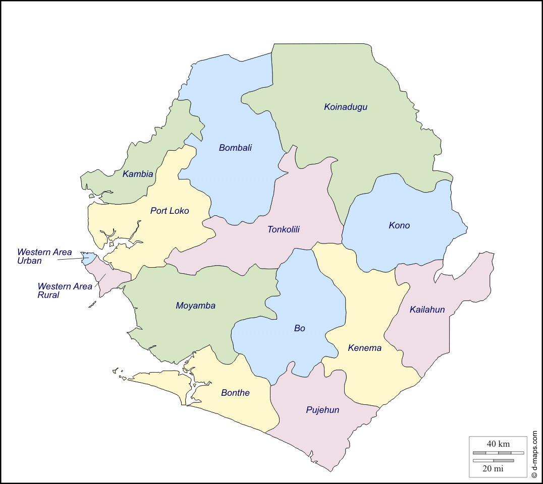

Sources: Andrew Reynolds, “Sierra Leone” in Dieter Nohlen, Michael Krennerich and Bernhard Thibaut, eds., Elections in Africa (New York: Oxford University Press 1999), 794; African Elections Database; Sierra Leone National Electoral Commission.